Great Sand Dunes National Park

Driving from Alamosa Colorado its around 32 miles (35min) to the Great Sand Dunes National Park and Preserve. taking the 160 and the 150. If you are going to camp at the park make a reservation first HERE it can and does get very busy. Or you can camp at the San Luis Lakes Wildlife Area on County lane 6 north. Just outside the park for free, as we did. With a great view back across to the sand dunes and the Rocky mountains.A great place to get sunrise photos.

Great sand dunes national park
Looking back at the Sand dunes from San Luis Lakes Wildlife Area Camping area
Great Sand Dunes National Park and Preserve Colorado

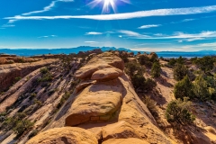
From the car park you walk out across a flat area first before you get the the dunes. We make up our minds to go left away from the crowds and sand boarders. Most people seem to go straight out form the car park and to the right and sand board. The one thing I like about getting away from the crowds. You can see all the foot prints of the animals that live in and around the dunes that come out at night to feed. Taking photos as the sun moves across the sky can also give you different and interesting affects of the dunes. The photo below was taken using a 15mm. down very low looking back up the sand ridge.

Sand Dunes Colorado
Light and Dark Sand Dune ridge under the sun, Colorado

Walking around the dunes I like to wear shoes as there are stoney areas and the sand does get hot at times. Water is a must have item for your backpack.

Milky Way Colorado
Milky Way over campers, San Luis Lakes wildlife area

Black Bears of Montana

Black bears can be found throughout Montana. From small towns to the mountains. Around the edge of Flathead Lake you have large areas of Cherry and Apple orchards. This brings them down to feed close to peoples homes.Making sightings of them around Flathead lake area very common

Black Bear Montana
Young Cinnamon colored Black Bear near the House

The above bear is cinnamon in color, and his friend below is more black in color. Black bear are not always Black

Black Bear
Black bear at tree line
Black bear eating apples
Bear bending over apple tree
Black Bear Flathead Lake Montana
Black Bear, Montana

Iguazu Water Falls -Argentina

Iguazu Falls are on the Iguazu river that runs along the Argentine-Brazilian border and is the world’s largest waterfall system. And a is must visit the next time you are in Argentina. With one Hotel that gives you a great view of the Iguazu Falls. With early access to some of the Jungle walking trails that are close by.

Sunrise
Sunrise form the Hotel

Watching the sunrise from the infinity pool at the Gran Melia Iguaza Hotel that looks straight across to the Iguazu falls. Morning coffee at hand.

Iguazu Falls
Looking up river to the Iguazu falls

Looking up to the Iguazu falls. Argentina on the right. Brazil on the left. From one of the many walking tracks that can be found on the Argentina side. Devils Throat falls are on the right under the Argentina flag. Iguazu National Park

Devil's Throat falls,Garganta do Diabo
Devil’s Throat water fall

Devil’s Throat (Garganta do Diabo)water fall is the most popular water fall in the park. It gets very crowded and very wet on the viewing platform. Being on the first train that leaves in the morning helps. Also having a local guide is even better. With their knowledge of the area on both sides of the river. Pointing out and finding the wildlife that live in the area. They can organize transport and take you over to the Brazilian side. Guiding you through passport control a little faster. As it gets very busy.
Iguazu falls from Brazilian side
Iguazu Falls from the Brazilian side

Looking up river to the Devil’s Throat falls from the Brazilian side lookout. A good viewing point to see the size of the water falls and Iguazu river.

American Alligator

American Alligator floating on surface Bluffton South Carolina near Hilton Head Island.
American Alligator (Alligatoridae)

On our last trip to South Carolina. To the town of Bluffton. I spend some time in the evenings and mornings photographing some of the local alligators that live around the town.Finding them is not hard as they can be found sun baking on banks around the waterways.They are more active in the mornings and evenings before it gets to hot.Making for more interesting photos at those times.Watching them moving around their environment looking for food.

American Alligator taking in the Sun
Sun baking on the dock in the late afternoon.Bluffton SC

Both the photos here. where taken with a Canon 70-300 lens.Not getting to close and having a second person to watch your back is also a good idea. Unfortunately some people are feeding them. This makes them less unafraid of humans in some areas that I have photographed them. Making them more dangerous if you don’t keep you eyes open. They can move fast if they want to.

American Alligator laying in swamp near Hilton head Island,South Carolina.
American Alligator Bluffton South Carolina
American Alligator
American Alligator Floating on the Surface,South Carolina.

American Alligator floating on the surface. In the waterways near Palmetto Bluff. South Carolina.

Back of Alligator

Looking down on the back of this Alligator. You can see the small fins or spikes. Their proper name are Scutes.

Wildlife of Antarctica

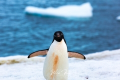
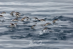
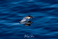
When in Antarctica you see a lot of penguins and seals. Crabeater and leopard seals sleeping and resting on Icebergs. In the Zodiac you can get very close to these seals. Walking through a Gentoo or Adelie penguin rookery on one of the outer Islands or Antarctica Peninsula mainland. Making friends as you go.

Minke Whale
Minke Whale breaching the surface
Minke whale going under the Zodiac

Mammals like the Minke whale can be seen through out the day from the ship. Also coming close to the Zodiac without fear. The Humpback whale is also around in large numbers. getting very close at times.

Interaction
Humpback whale checking out the Zodiac

Close encounters with a humpback whale. checking out the people in the Zodiac.

Humpback Whale
Breaching Humpback whale. Antarctica

Humpback whale breaching as the ship makes its way around some Icebergs.

Antarctica: Ice and Snow Landscapes

Start of Gunnel Channel
The Start of the Gunnel Channel

Leaving Ushuaia, Argentina. It took the ship 2 days at sea to cross the Drake passage to the top of the Antarctic peninsula. Weather and sea where kind with only a 4 to 5 meter swell. Heading south to the Antarctic circle and the wonders of Icebergs and landscapes of ice and snow.

Exploring the Icebergs
Giant Iceberg floating off shore

Icebergs of all sizes and shapes can be seen from the ship. It’s when you see them up close from the zodiac. that you can really appreciate the size and shapes that they come in.

Blue Ice
One of the many Blue Icebergs we came across

One of the many bright blue colored Icebergs that we came across. Some are so bright they stand out like a blue spotlight on the white landscape. If there was only one thing that you could takeaway from Antarctica. The size of the Icebergs and Glaciers would be one.

Antarctica Landscape
Face of Glacier

Moab Hiking

Have the winter blues got you down. Go hiking in Moab, Utah. Or take the mountain bike for a ride on one of the many trails. Arches National Park entrance is the closest to the town of Moab. Or the camping sites on the Colorado river just out of town. With many short hikes for that weekend away or longer stay. No need to get up super early to beat the heat.

Things to do in Moab

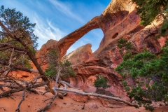
Without having to drive to far from Moab. Arches National Park is the easiest to get to if you only have the weekend. Devils Garden hike at the end of the road, 18miles. is a good place to start your hike. follow the trail over the rocky terrain and along high rock-fins to Double O Arch.

TIP. go early to miss the crowds. Sunrise through the rocks. Devils garden

The window and Double arch. There is a loop track that goes behind double arch and back to the car park.

Window Arch Moab
Loop track behind The Windows

Park Avenue. Very short with a great overview. or you can hike down the trail in the middle and end up back at the road near Courthouse towers. Delicate arch is also a nice hike and a little longer.

Balanced rock: very short walk. Sanddune arch is a nice walk that joins up with broken arch.

What every order you do these short and longer hikes. TAKE WATER even in the winter. 

Moab township

The township of Moab has lots to offer. In the way of restaurants and drinking holes.Moab brewery for that afternoon drink and food. Your morning Coffee . Moab restaurant guide . 4×4 rental. Mountain bike shop (Next to brewery)

Some great info can be found at OutsideHow on camping around Arches National Park. Also have a look at their Guides page for other National parks.

Bald Eagle

Bald Eagle Colorado

Having the Yampa river winding its way through Routt county makes for a great home year round for Bald eagles. catching trout on the river as fisherman watch with their mouths wide open.

Bald eagle in snow

National bird of United States of America

Bald eagle in flight


Bald eagle stretching wings

This is our year round resident bald eagle, with the Yampa river and fish filled ponds close by. life is good  

Home

Wharariki Beach. Archway Islands New Zealand

Wharariki Beach and Archway Islands hiking trails are to the west of Cape Farewell the most northern point of the South Island of New Zealand.Top of the Kiwi’s Head. Taking a short 20min hike through Department of Conservation land (Puponga farm park) that was once owned by the Riley’s. That walking track will bring you out at the top of a small sand dune with a view down the beach and the Archway Islands. Best time is at low tide and it can get very windy.  Seals can be found coming ashore to rest in some of the caves along the beach. Oyster catchers, black and white and black ones can be seen feeding along the waters edge with other sea birds.

Archway Islands - Wharariki Beach
Archway Islands. Wharariki Beach New Zealand
Walkers and Seal on Wharaiki Beach NZ
Walkers and Seal on Wharariki Beach

Getting to Wharariki Beach Golden By:

Leaving Collingwood follow the signs to Puponga, crossing a large one lane bridge over the Aorere River. Through Ferntown and on to Pakawau. Then turn right after crossing the bridge, keeping the ocean on your right. Once you reach Puponga you can drive up to the Farewell spit lookout. Like a good coffee and something to eat ? try the shop at the end of the road. Going back out to the main road turn right. When you get over the small hill and come out on the flat area again. The first turn on your left will take you up to the old red wool shed. From there you can walk over farm land to the coast and the seal cave and/or up to cape farewell. (nice walk) If you don’t stop here then keep on the main gravel road and you will of reach the parking area. The trail starts here over to Wharariki Beach and the Archway Islands. also from the car park. The hike down to green hills is through farm land with small lakes and bird life to view.

Wharariki Beach walk
Looking across to Wharariki Beach from above the car park

We stayed at the Collingwood Park Motel on the Main Street of Collingwood, Golden bay. very nice.

Home

Red Fox on the Hunt

Red Fox hunting for rodents under the snow
 
Watching this Red fox hunting for rodents was very interesting and entertaining  moving his head from side to side, listing to the rodents movements under the snow (about 2 feet deep) and then jumping up and nose diving into the snow and catching it on the first try, a warm meal on a cold winters day 
Fox jumping
     The Jump                           
 
Fox diving into the snow


The Dive
Fox and his pray
The prize